

Goodbye Blue Spruce Routes
This article originally appeared at Ops Group in October 2024. Shout out to their team. Ops Group is a great place to stay on top of the ever-changing international operations landscape.
NOTAM: Blue Spruce Routes have been deleted effective March 20, 2025. See the explanations and updates below.
3/20/2025. Reading time: 5 min

Single Engine Survival Paddle
Blue Spruce Routes
A new version of NAT Doc 007 is official as of 3/20/2025. The most significant changes are incorporating the removal of oceanic clearances (see NAT Operations) and the removal of the Blue Spruce Routes. No more Blue Spruce Routes! These have been around since WWI!!! Kind of.
First, we need to come to terms. There are two uses of the phrase "Blue Spruce Routes." The general, or popular level, understanding of the routes is how you cross the Atlantic with stops. They connect Canada, Greenland, Iceland, and Europe, and aircraft that cannot complete the journey non-stop fly these routes.
However, "Blue Spruce Routes" is also a technical term. Technically, since established in 1976, these routes have only existed within the NAT HLA (FL285-420), not above or below. In this sense, the routes are now extinct.
Their purpose was to allow aircraft with only one LRNU to cross within the NAT HLA. They are being dissolved now for a couple of reasons. First, with the addition of the Datalink Mandate (DLM) in the NAT HLA, hardly any aircraft equipped with datalink do not have two LRNUs. Secondly, the routes are essentially being substituted for the Iceland-Greenland corridor due to improvements in communications and surveillance coverage over the last decade in this area.
NAT Doc 007 1.3.6 lists that 2 LRNUs are required for NAT HLA operations. Only one LRNU has ever been required to fly above or below. 1.4.1 shows the workaround. You can be approved into the NAT HLA if you do not meet all the NAT HLA requirements when:
You fly within ATS surveillance coverage, and
You fly within VHF communication coverage, and
You're equipped with equipment capable of navigating your clearance
See the maps below for surveillance coverage, VHF coverage, and the DLM exemption area (i.e., Iceland-Greenland Corridor). So, the Southern Blue Spruce Route is gone, and the Northern has expanded to the corridor. Operations above or below the NAT HLA are unaffected.
While the name is officially gone, "Blue Spruce Routes" will probably still be a popular term for hop-skipping your way across the Atlantic. For posterity, I'm keeping the information below for reference. The article is updated for accuracy, but understand the term Blue Spruce Route is the generalized term for crossings.
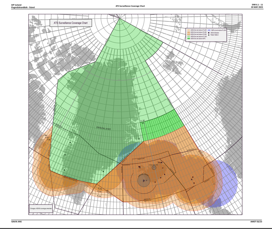
ATS Surveillance Coverage
Details
Most traffic crossing the North Atlantic Airspace (NAT) occurs from FL290-410 through the North Atlantic High Level Airspace (NAT HLA). Over the years, advances in navigation, communication, and surveillance equipment have led to additional requirements for operators so ATC can safely reduce aircraft spacing and pack more aircraft through the airspace.
For unrestricted access to the NAT HLA, operators need a list of equipment:
2 Long Range Navigation Units (LRNUs)
Outside VHF areas 2 LRCS are required – either 2x HF, or HF & Satcom/or CPDLC, for the other.
FANS 1/A equipment for the NAT Datalink Mandated airspace
Super-duper Datalink for the coveted PBCS Tracks (i.e. CPDLC capable of RCP240 + ADS-C capable of RSP180)
And for US operators, that equipment list is a prerequisite for several required LOAs:
A056 CPDLC Enroute, and Oceanic and Remote (PBCS)
B036 Oceanic and Remote Continental Navigation Using Multiple Long-Range Navigation Systems (M-LRNS), Aka. RNP 4 (and RNP 10)
B039 NAT HLA
B046 RVSM
D195 MEL (not technically required for a crossing, but might as well throw this one in)
The above is the ideal setup. But what if I fly old stuff, or new stuff, or broke stuff, or little stuff?
Old Stuff
To the formerly early adopters without the benefit of factory standard state-of-the-art equipment: let’s say your aircraft has LRNUs that are only capable of RNP 10, or your FANS equipment is RCP400 and RSP400.
All else being equal, the only limitation would be no PBCS tracks. And no T9/T290 either. All other tracks or random routes through the HLA are approved.
Is your equipment so old it doesn’t even have the above equipment? Consider yourself the same as broken, and keep reading…
New Stuff
You just closed on a shiny, new, well-equipped jet and have to ferry it across the pond, but you have no LOAs. In this case, you are altitude and route are limited. No RVSM or NAT HLA LOAs means the airspace
from FL290-410 is off-limits for you. If traffic permits, ATC may let you climb through the HLA above FL410, but you might want to plan fuel and route at FL280. Route-wise, without B036, you’re Blue Sprucing it flying the corridor.
If you only have some of the above-listed LOAs, also consider yourself broken.
Now, it gets a little more nuanced…
Broken Stuff
You’ve been spoofed, but only one GPS came back. When down to one LRNU (or you don’t have B036), fly the Iceland-Greeland Corridor (update!). With only one LRNU, you could fly through the NAT HLA along the corridor with approval if you stay within surveillance and VHF coverage and have the equipment to fly the assigned route. Otherwise, fly above or below the NAT HLA.
You’re down to one HF radio because you lost an HF and/or Satcom – Blue Spruce it stay within VHF coverage, (i.e., corridor), and altitude is your discretion. Your bad day just got worse, and you lost both HF radios – fly the corridor (VHF coverage) – but stay clear of Shanwick OCA.
HFs are back, but your Datalink konks out (CPDLC or ADS-C), or you don’t have A056. There are two options: stay within the Data Link Mandate (DLM) exemption area (the corridor) and fly any altitude. The DLM exemption area exists because you don’t need CPDLC in that area. Radio reception is pretty good throughout there! The second option is to fly above or below the NAT HLA.

DLM Exemption Area (i.e., Iceland-Greeland Cooridor)
Little Stuff
And if you get a wild hair to cross the Atlantic in an aircraft with only one LRNU, no HF radios, no Datalink, no LOAs, without the range to fly non-stop (like me), you guessed it, Blue Spruce it. It’s starting to sound like a cheesy rap song.
What’s a Blue Spruce?
It’s a Christmas tree native to the Rocky Mountains that you won’t see across the Atlantic on any of your stops. However, the Blue Spruce Routes are routes in and around the Atlantic connecting Canada, Greenland, Iceland, and the UK.
So why are they called the Blue Spruce Routes? Back when military aircraft had wooden propellers (sometimes made of spruce), they painted the tips blue. These aircraft had to make the trans-Atlantic journey along the now-known Blue Spruce Routes.

Nostalgia Map
Old, Extinct, No-more:
The routes are segments between countries. If you piece them together, the complete Southern Blue Spruce Route route headed East is:
YYR HOIST 58°N050°W OZN 61°N040°W 63°N030°W EPENI KFV OSKUM RATSU
The Northern route:
YFB SF DA SOPEN KFV ALDAN RATSU
Gray Areas
The Blue Spruce Routes Iceland-Greenland corridor provides exemptions from equipment and operational requirements because land-based radio transmitters along the route provide decent coverage, and route legs are short enough to complete a crossing without necessitating equipment redundancy.
Now, there are exemptions from the rules, and then there are gray areas. Despite all the relief these routes provide, one regulation remains: you must maintain two-way radio communication with ATC.
So far, much of the discussion is how high you can go, but what about how low?
VHF communications have improved significantly in the Atlantic in the last ten years. Both the northern and southern routes have VHF reception at appropriate altitudes. The longest stretch of water is between Canada and Greenland. On the southern route over this stretch of water, I have experienced adequate communication at FL250 and up. The northern route is good down to FL200. Iceland is fantastic - it’s almost like you’re in domestic airspace.
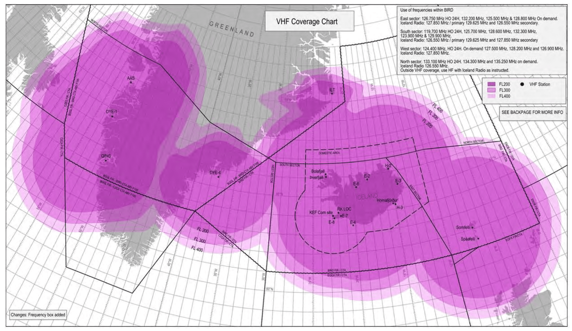
VHF Coverage Map
The gray area is when you plan to operate below these altitudes and are counting on utilizing another aircraft to relay position reports. By the letter, this is a no-no. The up-and-up solutions would be to rent a portable HF unit or containerize and ship the aircraft to Europe, both of which can be about $20k.
You can see the incentive to count on relays.
Are ferry pilots bending the rules? Let us descend, inception-style, one further layer down the list of the exceptions: ATC can waive the HF requirement for ferry, delivery, and special event flights. Ferry pilots have all the fun.
Summing up
So, you have the Blue Spruce Iceland -Greenland Corridor option if you need an exemption. You can operate with one LRNU, no HFs, no CPDLC, and no LOAs in the corridor. Otherwise, you can fly above or below the NAT HLA.
Is that all you need to know? Not even close!
If you are an experienced international operator, it may be an easy option to cross on a Blue Spruce Route. If you’re new, there is a lot to consider:
Flight planning, handling services, and local airport operations
Survival equipment requirements – especially for single-engine aircraft
Weather – it’s not great down low!
Human factors issues like fatigue and where to find the best beer (Reykjavik)
Keep reading!